Is Mount Shasta a Volcano? The Definitive Guide to Understanding This Cascade Giant
- October 4, 2026
Photo by Mazin Omron via Pexels
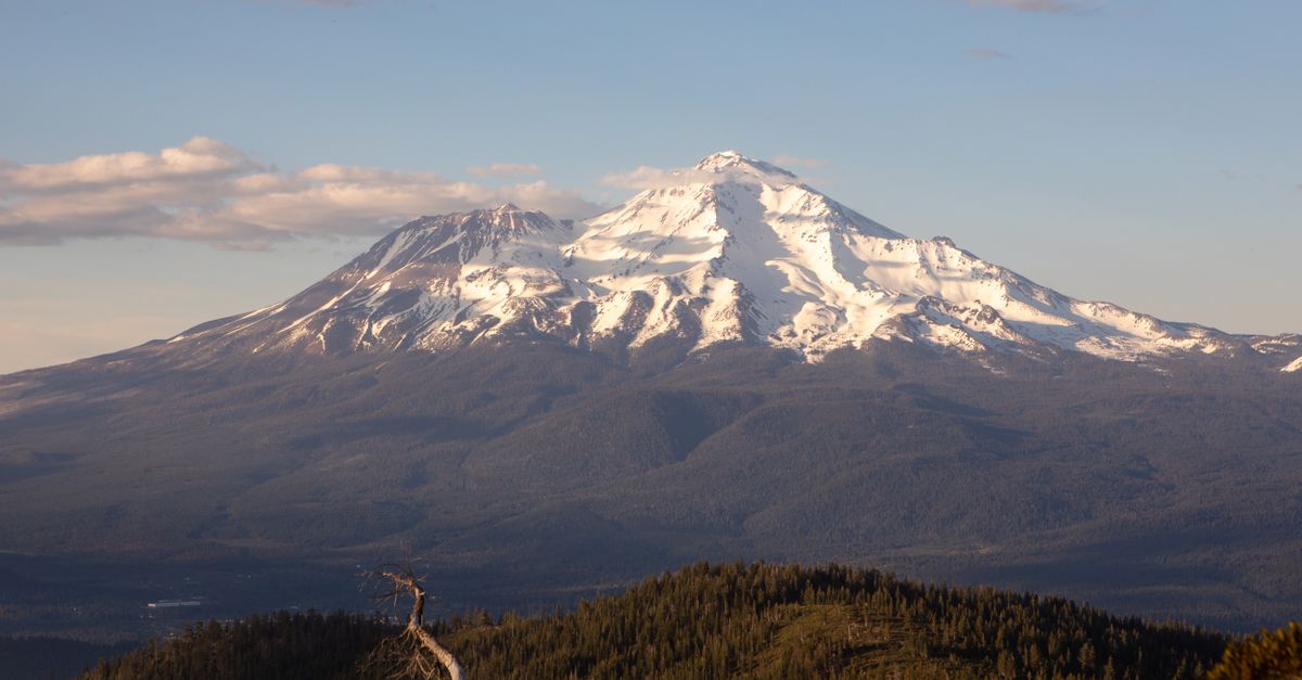
Mount Shasta is a volcano. Not a sleeping one, not a dormant one in the technical sense, but an active volcanic system that last erupted roughly 200 years ago, and one that USGS scientists rank among the highest-threat volcanoes in the United States. If you have ever looked up at that ice-crowned silhouette rising from Northern California and wondered what you were seeing, the geology is straightforward: you are looking at one of the most impressive stratovolcanoes in North America.
Understanding what Mount Shasta is, how it formed, and what that means for the land and people around it matters whether you are a curious traveler, a longtime resident, or someone who simply wants to know more about the dramatic landscape of the Pacific Northwest. This is not abstract geology. The shape of the land, the fertility of the valleys, the occasional ash fall, and the emergency planning for communities downstream all trace back to the fact that Mount Shasta is a volcano.
What Type of Volcano Is Mount Shasta
Mount Shasta is classified as a stratovolcano, also known as a composite volcano. This is the classic volcano shape, the steep-sided, conical mountain with a central summit crater that most people picture when they think "volcano." Stratovolcanoes are built through alternating eruptions of viscous lava flows and explosive eruptions that deposit ash and pyroclastic material. Over thousands of years, layer upon layer of this material accumulates, creating the mountain's characteristic profile.
The lava that erupts from stratovolcanoes like Mount Shasta is andesitic in composition, named after the Andes Mountains where similar volcanic activity occurs. This magma is relatively viscous, meaning it does not flow as easily as the basaltic lava seen at volcanoes like those in Hawaii. Instead, it tends to pile up near the vent, building steep slopes that can exceed 30 degrees. The result is the iconic symmetrical cone that makes Mount Shasta stand out against the Northern California sky.
What makes Mount Shasta unusual within the Cascade Range is its classification as a compound volcano. Rather than a single, unified cone, Mount Shasta is built from four overlapping volcanic edifices, distinct cones that formed at different times and partially merged into the massive mountain we see today. This complexity adds to the volcano's geological interest and contributes to the multiple summit peaks that characterize the skyline.
Mount Shasta's Geology and the Four Cones
The four cones that compose Mount Shasta are known as the Hotlum cone, the Sargents Ridge cone, the Misery Hill cone, and the Shastina cone. Each represents a distinct phase of volcanic activity, with their own timeline of eruptions and their own contributions to the mountain's overall mass.
The Hotlum cone forms the current main summit and has been the primary source of activity in recent geological time. This cone has produced the most voluminous eruptions in Mount Shasta's history, including some of the large debris avalanches that have shaped the mountain's lower flanks. Eruptions from Hotlum have produced both viscous lava flows that crept down the slopes and explosive events that sent ash across the surrounding region.
Misery Hill, despite its name, is one of the younger features on the mountain. This cone sits near the summit and is composed of material erupted from the central vent system. Its relative youth means it is less eroded than some of the older cones, preserving more of its original volcanic morphology.
Sargents Ridge and Shastina represent earlier phases of the volcano's construction. Shastina, on the western flank, is itself a substantial volcanic cone. Were it a standalone mountain in most of the country, it would be considered a significant peak in its own right. Its presence as a satellite cone on Mount Shasta gives some indication of the scale of the overall volcanic system.
Together, these four cones create a volcanic complex that covers roughly 150 square miles and contains approximately 150 cubic miles of material, making Mount Shasta one of the largest stratovolcanoes in the Cascades by volume. The mountain's mass is greater than the combined volume of many other Cascade peaks.
The Cascade Volcanic Arc and Plate Tectonics
Mount Shasta does not exist in geological isolation. It is one of approximately 20 major volcanic centers that form the Cascade Volcanic Arc, a chain of volcanoes stretching from British Columbia to Northern California along the western edge of North America. This arc is the surface expression of a deep geological process that has shaped the Pacific Northwest for tens of millions of years.
The driver of Cascade volcanism is the subduction of the Juan de Fuca Plate beneath the North American Plate. The Juan de Fuca Plate is a remnant of the once-massive Farallon Plate, and it is slowly being pushed beneath the continental margin at a rate of roughly 1.5 to 2 inches per year. As the oceanic plate descends into the mantle, it carries water and other volatiles trapped in the crust and sediments. These materials lower the melting point of the surrounding mantle rock, generating magma.
This magma, less dense than the surrounding rock, rises toward the surface. Along the Cascade Arc, it accumulates in magma chambers several miles beneath the volcanoes, feeding eruptions at the surface. The result is the string of stratovolcanoes that defines the Cascades, from Mount Baker in Washington to Mount Lassen in California, with Mount Shasta occupying a central position in this chain.
The subduction zone that drives Mount Shasta is not a uniform system. Scientists have identified multiple areas of partial melt beneath the volcano, suggesting a complex plumbing system with multiple sources of magma feeding the surface. This complexity is one reason why Mount Shasta has produced such massive eruptions over its lifespan. The volcano has access to substantial magma reserves.
How Mount Shasta Compares to Other Cascade Volcanoes
Mount Shasta stands among the tallest and most massive volcanoes in the Cascades, though it often receives less attention than some of its neighbors. At 14,179 feet, it is the second-highest volcano in the Cascade Range, surpassed only by Mount Rainier in Washington at 14,411 feet. This puts Shasta ahead of other prominent peaks like Mount Adams, Mount Hood, and Mount Shasta's southern neighbor, Lassen Peak.
By volume, Mount Shasta is among the largest. Some estimates suggest it contains more material than Mount Rainier, despite being slightly shorter. The combination of height and mass makes Shasta one of the most gravitationally imposing features in the western United States.
In terms of eruptive history, Mount Shasta has a track record that compares to the most active Cascade volcanoes. In the past 10,000 years, Shasta has produced multiple significant eruptions, including some of the largest known explosive events in the Cascades. The most recent eruption occurred around 1786, with historical accounts describing volcanic activity in the late 18th century.
For comparison, Mount St. Helens is perhaps the most well-known Cascade volcano due to its catastrophic 1980 eruption, but it is significantly smaller than Shasta. Mount Rainier, while taller, has a less voluminous edifice. Mount Shasta's combination of size, activity level, and proximity to populated areas makes it a significant focus of monitoring and hazard planning.
Is Mount Shasta Active? USGS Threat Assessment
Mount Shasta is classified as an active volcano by the United States Geological Survey. The volcano has erupted multiple times within the past 4,000 years, and the USGS considers it one of the most hazardous volcanoes in the United States.
The USGS National Volcano Threat Score places Mount Shasta in the second-highest threat category, a designation reflecting the combination of its eruptive potential, its proximity to population centers, and the vulnerability of infrastructure in the surrounding area. Communities like Mount Shasta, Weed, and Dunsmuir lie in the shadow of the volcano, with the McCloud and Sacramento Rivers flowing from its flanks, rivers that could carry volcanic mudflows, known as lahars, downstream in the event of a significant eruption or glacial outburst.
Unlike some volcanoes that show obvious signs of activity through persistent seismicity or gas emissions, Mount Shasta's current state is relatively quiet. The USGS monitors the volcano through a network of seismometers, GPS stations, and satellite-based deformation measurements. No unusual activity has been detected in recent years. However, "active" in volcanic terms does not mean "currently erupting." It means the system still has the potential to erupt, which Mount Shasta clearly does.
The most significant hazards associated with Mount Shasta are not explosive eruptions alone but the secondary effects of volcanic activity. Lahars, generated by melting ice during eruptions or by the collapse of unstable volcanic material, could travel tens of miles downstream. Ash fall could affect areas hundreds of miles away. Pyroclastic flows, superheated clouds of gas and volcanic rock, would be localized to the immediate vicinity but devastating within that zone.
What This Means for Visitors and Residents
Understanding that Mount Shasta is an active volcano has practical implications for anyone who spends time in the area.
The most immediate consideration is awareness. While the probability of a significant eruption in any given year is low, it is not zero. Visitors to Mount Shasta should understand that they are recreating in an active volcanic landscape, complete with the inherent risks that entails. This means paying attention to any official advisories, understanding the signs of volcanic activity, and knowing how to respond in the unlikely event of an emergency.
Beyond hazard awareness, recognizing Mount Shasta as a volcano enriches the experience of being in its presence. The mountain's shape, its glaciers, its rugged summit, and the fertility of the valleys below are all products of volcanic processes. The same forces that create risk also create the dramatic landscape that draws people to the area. Understanding the geology adds another dimension to hiking, camping, and soaking in the hot springs that dot the region.
For residents and local officials, volcanic hazard planning is an ongoing responsibility. Evacuation routes, community notification systems, and infrastructure considerations all factor into long-term planning. The USGS and local emergency management agencies maintain partnerships to ensure that communities are prepared should volcanic activity increase.
Mount Shasta is not a relic of a volcanic past. It is a living geological system, still capable of transforming the landscape and affecting human communities. Recognizing this fact is the first step toward coexisting with the mountain safely and respectfully.